In 2021, after taking possession of our Adventure Van, we embarked on a five-month trip to the East Coast and back across the southern U.S. We committed ourselves to visiting as many of those places we had passed on various coast-to-coast moves between Navy assignments. After visiting friends in Scottsdale, Arizona, we headed north into the Navajo Nation. What follows is an unpublished account of the day we spent exploring Canyon de Chelly.
The Navajo Nation, including ancestral locations of the Anasazi, Hopi, Zuni, and Apache, covers most of the northeastern corner of Arizona, extending into Utah and New Mexico, and contains many wonderous geological and archeological sites. One of the remarkable sites is Canyon de Chelly (pronounced Canyon “de shay”) located near the community of Chinle.

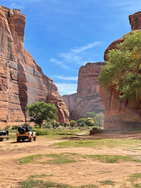
Running east from Chinle for approximately 25 miles Canyon de Chelly has two main channels. With numerous narrower branches included, there are more than 131 square miles of red limestone canyons to amaze you. The waters sculpting these dramatic gorges flow west from New Mexico’s Chuska mountains, continuing their century’s old chiseling efforts during Spring snow run-off, summer monsoon rains, and the thunderstorms’ torrential flash floods. For visitors to the area, most of the year the canyon floor is nearly dry and most always passable by guided 4×4 tours, horseback or on foot with only muddy puddles and soft wet sand to hint at the presence of nature’s powerful tools.
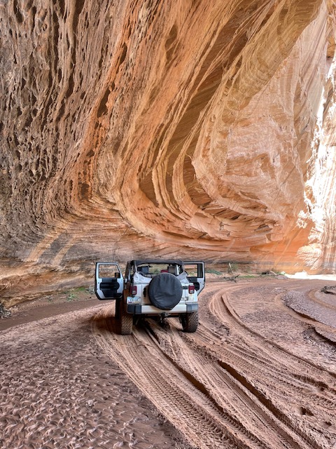
Canyon de Chelly National Monument is a Navajo Nation Park managed by both the Navajo Nation and the U.S. National Park Service. While the Park Service provides rangers and runs a Welcome Center just outside the entrance to the canyon, the professional Navajo guides are the visible tour operators for park access. Each main wing of the canyon is topped by an access road leading to viewing overlooks of the more important archeological and geological sites. Access to the canyon rim is, however, strictly limited to those overlooks as most of the land is privately. Because of the physical length of the canyons and the difficulty in traversing the ever-changing landscape in the narrow canyon bottoms, the best way to visit the most impressive sites is via four-wheel drive vehicle. On our early-October visit to the park, we scheduled a six-hour 4×4 tour and only visited half of one of the canyon legs.
We booked our tour through Canyon de Chelly Tours (canyondechellytours.com). Our Navajo guide Richard, from the community of Many Farms, has guided tours of Canyon de Chelly for over four years. We road in a Jeep Wrangler and needed every bit of its four-wheel drive and high ground clearance to navigate the soft canyon bottom and deeply rutted trails. Richard said, “Most of the canyon bottom is privately owned by Navajo families who have farmed and run livestock here for countless generations.” At the junction of several canyons, where the floods of eons have carved a wider opening, we saw orchards and fields where corn is grown in the same manner as it has been for generations, with the annual floods renewing the soil.
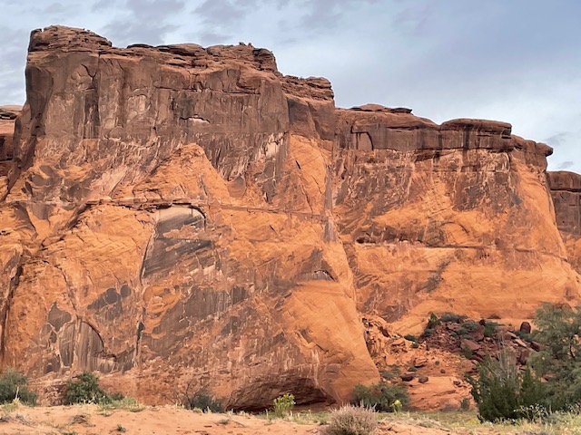
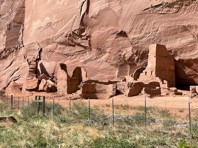
Besides some of Mother Nature’s most awe-inspiring handiwork, Canyon de Chelly contains remnants of past civilizations. Located throughout the labyrinth are evidence of ancient communities in the form of mud-brick dwellings, petroglyphs and paintings chronicling the presence of the Ancestral Pueblo peoples who inhabited these canyons for centuries. Most likely forebearers of the Hopi and Zuni, the Anasazi people sought safety and livelihood in these canyons. They built elaborate communal complexes onto ledges and under overhanging rock walls to protect themselves from the elements and roving enemies.

Richard pointed out that “Houses on the north side of the east-west running canyon were built in areas where they would by warmed by the sun during the winter and those on the south side were built to take advantage of the shade for cooling in the summer.” Scientific dating of artifacts found in the canyons indicate the height of Ancestral Pueblo inhabitation lasted from roughly 900-1100 AD.
Richard indicated it is not known why they left, whether because of changing climactic conditions, several years of severely reduced rain and snow fall, or whether they were forced out by other peoples. Richard also pointed out the Ancestral Pueblo peoples were of small stature indicated both by the size of the openings to their dwellings and the carved foot and hand holds they used to scale the canyon walls. One of the more interesting observations is the height of the housing sites, now 50-80 feet above the current canyon floor. It is easy to think that the Anasazi must have chosen these high perches for safety from both intruders and surging flood waters. If so, it must have been incredibly difficult to live and work on those narrow ledges well above the canyon floor. The reality is as Richard explains, “The areas chosen by the Anasazi indicate the level of the canyon floor when they lived there. Erosion has dropped the canyon floor over 50 feet in the last thousand years.”

The other item the Anasazi left were significant rock art paintings and carvings. Murals containing animal imagery, bighorn sheep, elk, deer, and birds abound. Symbols of believed religious significance including the sun, moon, and human-like figures are numerous as well. According to Richard “The birds are thought to symbolize the flight of deceased individuals into the afterlife.” Additional marks next to the birds could be construed as a way of counting the number of people who had died during a certain period. We also saw numerous man-like symbols with both arms either raised or pointing downward. Richard believes this represents symbols of welcoming (arms raised) or warning (arms down, possibly indicating burial sites).
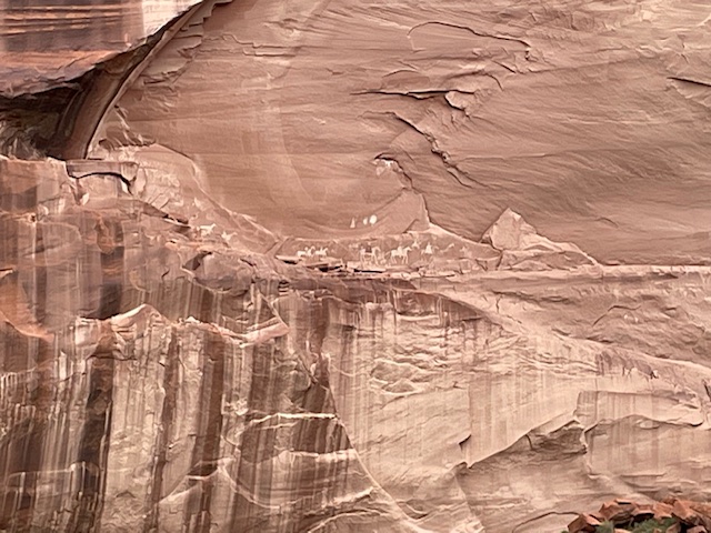
One of the most famous murals was not produced by the Anasazi but came from later inhabitants, perhaps Hopi or Zuni ancestors and is dated from the late 1500 or early 1600s. It is a large painting chronicling the arrival of Spanish conquistadors and their horses. There are several figures wearing capes and helmets, carrying long lances and riding horses. One of the figures has the sign of a cross on his cape, either indicating he was a priest or possibly the leader of the procession. The artwork and symbology are in such detail that the subject and significance are unmistakable.
By the 1700s, the Navajo people had moved into the region and began inhabiting and farming the canyon where water runs almost continually. There are ruins of adobe and mud-block buildings closer to the current canyon floor and ownership or responsibility for plots of land and side canyons can be traced to the current local families. One of the more tragic events in the canyon occurred in 1864 when elements of the U.S. Army calvary were sent to force the Navajo inhabitants onto a reservation. A deadly game of hide and seek developed in which the Navajo used their knowledge of the land and their skills at climbing and survival to remain at large in the canyon. A small band hid at the top of a flat rock pinnacle which was surrounded by soldiers. After a standoff lasting weeks and resulting in many deaths from starvation and thirst, the remaining holdouts were forced to surrender. This is one of the reasons the Navajo Nation considers this area sacred and maintains firm control of access and activities within the canyon.
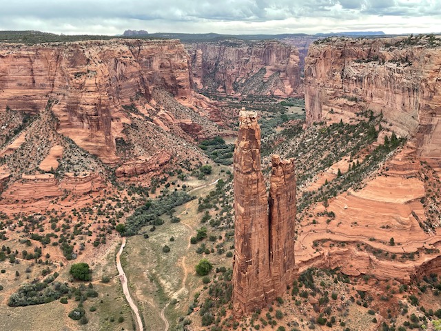
After the end of our remarkable six-hour tour of the canyon floor, we drove along the south rim to see some of the spectacles we missed in the second of the two main canyon arms. The most famous of the geologic formations is Spider Rock. Spider Rock is an 800 foot tall spire that rises almost directly from the canyon floor. It has been the scene of television commercials and played a starring role in the movie McKenna’s Gold. Named in honor of the Navajo figure “The Spider Women” the thin, vertical, shaft formed at the confluence of three canyons and appears so delicate that it is hard to believe that it is freestanding.
Canyon de Chelly is not very well known compared to its nearby larger cousins the Grand Canyon or Antelope Canyon, also in the Navajo Nation. In some ways, we believe the Navajo are happy to have it that way. The area has such profound cultural, historic, and religious significance and is still home to Navajo families who work the land that they are satisfied that it not become a tourist mecca. But, the ability to get very close to some of nature’s most unforgettable creations in an atmosphere that is as authentic as it gets makes Canyon de Chelly a very special place for visitors. For those who are fans of the incredible landscape and cultural wonders of the American Southwest, it should not be missed.

Leave a comment